|
|
|||||||||||||||||
| Point ID: 8823 | Downloads | Plots | Site Data | Code: 12421 |
|
|
|||||||||||||||||
| Download | |
|---|---|
| Site Descriptor Information | Site Time Series Data |
| Link to all available data | |
| View: | Time Series | All |
| Units: | mm |
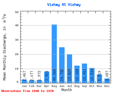
| Statistic | Jan | Feb | Mar | Apr | May | Jun | Jul | Aug | Sep | Oct | Nov | Dec | Annual |
|---|---|---|---|---|---|---|---|---|---|---|---|---|---|
| Mean | 2.47 | 2.08 | 1.97 | 7.92 | 40.57 | 24.73 | 19.83 | 12.17 | 13.45 | 10.53 | 5.92 | 3.09 | 12.10 |
| Standard Deviation | 0.80 | 0.77 | 0.65 | 7.08 | 15.34 | 9.15 | 14.31 | 8.40 | 8.78 | 4.16 | 2.58 | 1.15 | 3.17 |
| Min | 1.36 | 0.98 | 1.04 | 0.96 | 16.40 | 11.70 | 6.92 | 2.81 | 4.93 | 4.16 | 2.16 | 0.45 | 7.77 |
| Max | 4.29 | 3.96 | 3.59 | 24.20 | 77.90 | 44.20 | 55.80 | 35.60 | 42.20 | 20.60 | 10.90 | 5.11 | 20.94 |
| Coefficient of Variation | 0.33 | 0.37 | 0.33 | 0.89 | 0.38 | 0.37 | 0.72 | 0.69 | 0.65 | 0.39 | 0.44 | 0.37 | 0.26 |
 Return to R-Arctic Net Home Page