|
|
|||||||||||||||||
| Point ID: 8823 | Downloads | Plots | Site Data | Code: 12421 |
|
|
|||||||||||||||||
| Download | |
|---|---|
| Site Descriptor Information | Site Time Series Data |
| Link to all available data | |
| View: | Time Series | All |
| Units: | m3/s |
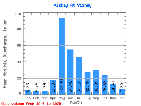
| Statistic | Jan | Feb | Mar | Apr | May | Jun | Jul | Aug | Sep | Oct | Nov | Dec | Annual |
|---|---|---|---|---|---|---|---|---|---|---|---|---|---|
| Mean | 6.23 | 4.78 | 4.98 | 19.37 | 102.49 | 60.48 | 50.10 | 30.74 | 32.89 | 26.61 | 14.47 | 7.80 | 360.26 |
| Standard Deviation | 2.03 | 1.77 | 1.63 | 17.30 | 38.75 | 22.36 | 36.16 | 21.21 | 21.46 | 10.50 | 6.32 | 2.90 | 94.43 |
| Min | 3.44 | 2.26 | 2.63 | 2.35 | 41.43 | 28.61 | 17.48 | 7.10 | 12.05 | 10.51 | 5.28 | 1.14 | 231.37 |
| Max | 10.84 | 9.12 | 9.07 | 59.18 | 196.81 | 108.08 | 140.97 | 89.94 | 103.19 | 52.04 | 26.65 | 12.91 | 623.58 |
| Coefficient of Variation | 0.33 | 0.37 | 0.33 | 0.89 | 0.38 | 0.37 | 0.72 | 0.69 | 0.65 | 0.39 | 0.44 | 0.37 | 0.26 |
 Return to R-Arctic Net Home Page