|
|
|||||||||||||||||
| Point ID: 8805 | Downloads | Plots | Site Data | Code: 12285 |
|
|
|||||||||||||||||
| Download | |
|---|---|
| Site Descriptor Information | Site Time Series Data |
| Link to all available data | |
| View: | Time Series | All |
| Units: | mm |
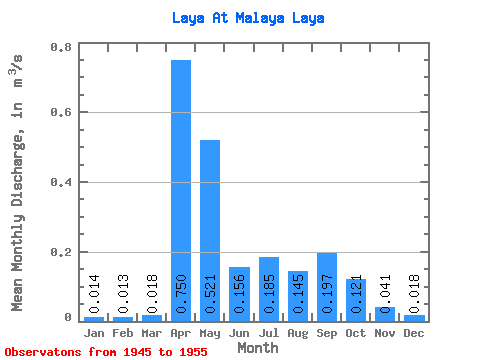
| Statistic | Jan | Feb | Mar | Apr | May | Jun | Jul | Aug | Sep | Oct | Nov | Dec | Annual |
|---|---|---|---|---|---|---|---|---|---|---|---|---|---|
| Mean | 0.01 | 0.01 | 0.02 | 0.75 | 0.52 | 0.16 | 0.18 | 0.14 | 0.20 | 0.12 | 0.04 | 0.02 | 0.19 |
| Standard Deviation | 0.01 | 0.01 | 0.01 | 0.60 | 0.29 | 0.12 | 0.35 | 0.22 | 0.32 | 0.13 | 0.03 | 0.01 | 0.12 |
| Min | 0.01 | 0.01 | 0.01 | 0.19 | 0.19 | 0.06 | 0.02 | 0.01 | 0.03 | 0.03 | 0.01 | 0.01 | 0.07 |
| Max | 0.03 | 0.03 | 0.05 | 1.89 | 1.07 | 0.43 | 1.15 | 0.75 | 1.06 | 0.39 | 0.10 | 0.04 | 0.46 |
| Coefficient of Variation | 0.51 | 0.53 | 0.80 | 0.80 | 0.55 | 0.77 | 1.88 | 1.53 | 1.64 | 1.06 | 0.79 | 0.57 | 0.64 |
 Return to R-Arctic Net Home Page