|
|
| Point ID: 8805 | Downloads | Plots | Site Data | Code: 12285 |
|
| Download | |
|---|---|
| Site Descriptor Information | Site Time Series Data |
| Link to all available data | |
|
|
|
| View: | Statistics | All |
| Units: | mm |
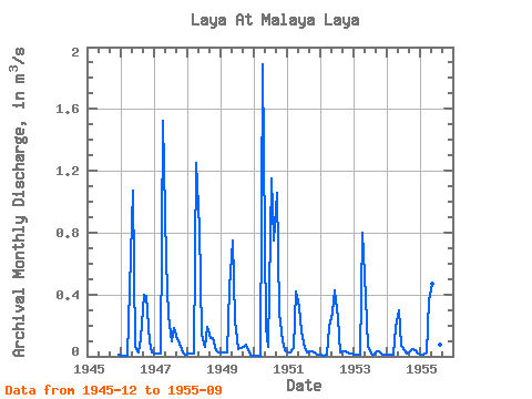
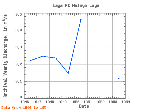
| Year | Jan | Feb | Mar | Apr | May | Jun | Jul | Aug | Sep | Oct | Nov | Dec | Annual | 1945 | 0.01 | 1946 | 0.01 | 0.01 | 0.01 | 0.44 | 1.07 | 0.06 | 0.02 | 0.12 | 0.40 | 0.39 | 0.10 | 0.03 | 0.22 | 1947 | 0.01 | 0.02 | 0.02 | 1.52 | 0.62 | 0.26 | 0.10 | 0.18 | 0.11 | 0.08 | 0.02 | 0.01 | 0.25 | 1948 | 0.02 | 0.02 | 0.02 | 1.25 | 0.83 | 0.14 | 0.06 | 0.19 | 0.12 | 0.12 | 0.04 | 0.03 | 0.24 | 1949 | 0.03 | 0.03 | 0.03 | 0.44 | 0.75 | 0.23 | 0.04 | 0.05 | 0.06 | 0.07 | 0.03 | 0.01 | 0.15 | 1950 | 0.01 | 0.01 | 0.01 | 1.89 | 0.19 | 0.06 | 1.15 | 0.75 | 1.06 | 0.28 | 0.09 | 0.04 | 0.46 | 1951 | 0.02 | 0.02 | 0.05 | 0.42 | 0.32 | 0.16 | 0.05 | 0.03 | 0.03 | 0.03 | 0.02 | 0.01 | 0.10 | 1952 | 0.01 | 0.01 | 0.01 | 0.19 | 0.28 | 0.43 | 0.25 | 0.02 | 0.03 | 0.04 | 0.02 | 0.01 | 0.11 | 1953 | 0.01 | 0.01 | 0.01 | 0.80 | 0.38 | 0.06 | 0.02 | 0.01 | 0.03 | 0.03 | 0.01 | 0.01 | 0.12 | 1954 | 0.01 | 0.01 | 0.01 | 0.19 | 0.30 | 0.07 | 0.04 | 0.02 | 0.04 | 0.05 | 0.04 | 0.02 | 0.07 | 1955 | 0.01 | 0.01 | 0.02 | 0.36 | 0.47 | 0.09 | 0.10 | 0.08 | 0.09 |
|---|
 Return to R-Arctic Net Home Page