|
|
|||||||||||||||||
| Point ID: 8801 | Downloads | Plots | Site Data | Code: 12266 |
|
|
|||||||||||||||||
| Download | |
|---|---|
| Site Descriptor Information | Site Time Series Data |
| Link to all available data | |
| View: | Time Series | All |
| Units: | mm |
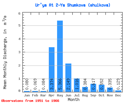
| Statistic | Jan | Feb | Mar | Apr | May | Jun | Jul | Aug | Sep | Oct | Nov | Dec | Annual |
|---|---|---|---|---|---|---|---|---|---|---|---|---|---|
| Mean | 0.08 | 0.07 | 0.08 | 3.37 | 5.37 | 2.15 | 1.02 | 0.38 | 0.62 | 0.55 | 0.34 | 0.13 | 1.19 |
| Standard Deviation | 0.09 | 0.09 | 0.09 | 2.47 | 3.60 | 1.04 | 1.32 | 0.29 | 0.76 | 0.64 | 0.36 | 0.14 | 0.53 |
| Min | 0.00 | 0.00 | 0.00 | 0.42 | 1.42 | 1.08 | 0.07 | 0.01 | 0.03 | 0.07 | 0.04 | 0.00 | 0.52 |
| Max | 0.28 | 0.26 | 0.24 | 8.76 | 15.20 | 4.15 | 4.97 | 0.98 | 2.51 | 2.12 | 1.20 | 0.47 | 2.47 |
| Coefficient of Variation | 1.08 | 1.25 | 1.10 | 0.73 | 0.67 | 0.48 | 1.30 | 0.76 | 1.24 | 1.17 | 1.07 | 1.07 | 0.44 |
 Return to R-Arctic Net Home Page