|
|
|||||||||||||||||
| Point ID: 8801 | Downloads | Plots | Site Data | Code: 12266 |
|
|
|||||||||||||||||
| Download | |
|---|---|
| Site Descriptor Information | Site Time Series Data |
| Link to all available data | |
| View: | Time Series | All |
| Units: | m3/s |
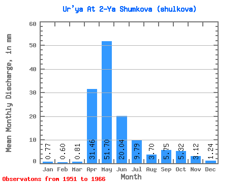
| Statistic | Jan | Feb | Mar | Apr | May | Jun | Jul | Aug | Sep | Oct | Nov | Dec | Annual |
|---|---|---|---|---|---|---|---|---|---|---|---|---|---|
| Mean | 0.77 | 0.61 | 0.81 | 31.46 | 51.69 | 20.04 | 9.79 | 3.69 | 5.75 | 5.31 | 3.12 | 1.25 | 135.48 |
| Standard Deviation | 0.83 | 0.76 | 0.89 | 23.06 | 34.65 | 9.70 | 12.74 | 2.80 | 7.11 | 6.19 | 3.33 | 1.33 | 60.15 |
| Min | 0.00 | 0.00 | 0.00 | 3.92 | 13.68 | 10.07 | 0.68 | 0.10 | 0.24 | 0.66 | 0.33 | 0.00 | 58.99 |
| Max | 2.70 | 2.28 | 2.31 | 81.68 | 146.42 | 38.69 | 47.88 | 9.44 | 23.40 | 20.42 | 11.19 | 4.53 | 280.79 |
| Coefficient of Variation | 1.08 | 1.25 | 1.10 | 0.73 | 0.67 | 0.48 | 1.30 | 0.76 | 1.24 | 1.17 | 1.07 | 1.07 | 0.44 |
 Return to R-Arctic Net Home Page