|
|
|||||||||||||||||
| Point ID: 8792 | Downloads | Plots | Site Data | Code: 12227 |
|
|
|||||||||||||||||
| Download | |
|---|---|
| Site Descriptor Information | Site Time Series Data |
| Link to all available data | |
| View: | Time Series | All |
| Units: | mm |
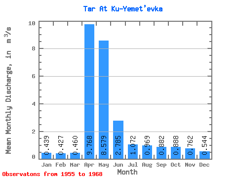
| Statistic | Jan | Feb | Mar | Apr | May | Jun | Jul | Aug | Sep | Oct | Nov | Dec | Annual |
|---|---|---|---|---|---|---|---|---|---|---|---|---|---|
| Mean | 0.44 | 0.43 | 0.46 | 9.77 | 8.58 | 2.79 | 1.07 | 0.97 | 0.88 | 0.89 | 0.76 | 0.54 | 2.36 |
| Standard Deviation | 0.18 | 0.18 | 0.17 | 6.21 | 6.24 | 2.49 | 0.78 | 0.72 | 0.60 | 0.42 | 0.26 | 0.17 | 1.18 |
| Min | 0.14 | 0.20 | 0.21 | 1.96 | 1.00 | 0.45 | 0.36 | 0.49 | 0.49 | 0.55 | 0.45 | 0.30 | 0.59 |
| Max | 0.79 | 0.83 | 0.76 | 26.20 | 21.50 | 8.84 | 2.93 | 3.06 | 2.69 | 1.93 | 1.27 | 0.81 | 5.02 |
| Coefficient of Variation | 0.42 | 0.41 | 0.37 | 0.64 | 0.73 | 0.90 | 0.73 | 0.75 | 0.68 | 0.48 | 0.33 | 0.31 | 0.50 |
 Return to R-Arctic Net Home Page