|
|
|||||||||||||||||
| Point ID: 8792 | Downloads | Plots | Site Data | Code: 12227 |
|
|
|||||||||||||||||
| Download | |
|---|---|
| Site Descriptor Information | Site Time Series Data |
| Link to all available data | |
| View: | Time Series | All |
| Units: | m3/s |
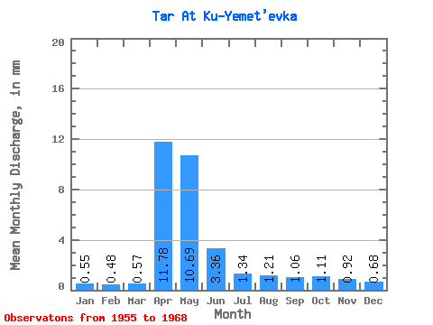
| Statistic | Jan | Feb | Mar | Apr | May | Jun | Jul | Aug | Sep | Oct | Nov | Dec | Annual |
|---|---|---|---|---|---|---|---|---|---|---|---|---|---|
| Mean | 0.55 | 0.48 | 0.57 | 11.78 | 10.69 | 3.36 | 1.33 | 1.21 | 1.06 | 1.11 | 0.92 | 0.68 | 34.71 |
| Standard Deviation | 0.23 | 0.20 | 0.21 | 7.49 | 7.78 | 3.01 | 0.97 | 0.90 | 0.72 | 0.53 | 0.31 | 0.21 | 17.31 |
| Min | 0.17 | 0.23 | 0.26 | 2.36 | 1.25 | 0.54 | 0.45 | 0.61 | 0.59 | 0.69 | 0.54 | 0.37 | 8.64 |
| Max | 0.98 | 0.94 | 0.95 | 31.59 | 26.78 | 10.66 | 3.65 | 3.81 | 3.24 | 2.40 | 1.53 | 1.01 | 73.73 |
| Coefficient of Variation | 0.42 | 0.41 | 0.37 | 0.64 | 0.73 | 0.90 | 0.73 | 0.75 | 0.68 | 0.48 | 0.33 | 0.31 | 0.50 |
 Return to R-Arctic Net Home Page