|
|
|||||||||||||||||
| Point ID: 8787 | Downloads | Plots | Site Data | Code: 12205 |
|
|
|||||||||||||||||
| Download | |
|---|---|
| Site Descriptor Information | Site Time Series Data |
| Link to all available data | |
| View: | Time Series | All |
| Units: | mm |
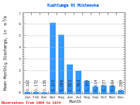
| Statistic | Jan | Feb | Mar | Apr | May | Jun | Jul | Aug | Sep | Oct | Nov | Dec | Annual |
|---|---|---|---|---|---|---|---|---|---|---|---|---|---|
| Mean | 0.16 | 0.17 | 0.14 | 6.10 | 5.09 | 2.52 | 1.96 | 1.11 | 0.61 | 0.73 | 0.68 | 0.29 | 1.68 |
| Standard Deviation | 0.09 | 0.17 | 0.10 | 2.38 | 2.45 | 2.17 | 1.83 | 1.30 | 0.59 | 0.46 | 0.58 | 0.13 | 0.52 |
| Min | 0.00 | 0.00 | 0.00 | 1.06 | 1.21 | 0.35 | 0.13 | 0.14 | 0.20 | 0.35 | 0.27 | 0.16 | 1.03 |
| Max | 0.26 | 0.60 | 0.31 | 8.77 | 9.12 | 6.44 | 5.48 | 4.18 | 1.88 | 1.79 | 2.20 | 0.55 | 2.58 |
| Coefficient of Variation | 0.56 | 1.00 | 0.75 | 0.39 | 0.48 | 0.86 | 0.93 | 1.18 | 0.96 | 0.64 | 0.85 | 0.44 | 0.31 |
 Return to R-Arctic Net Home Page