|
|
|||||||||||||||||
| Point ID: 8787 | Downloads | Plots | Site Data | Code: 12205 |
|
|
|||||||||||||||||
| Download | |
|---|---|
| Site Descriptor Information | Site Time Series Data |
| Link to all available data | |
| View: | Time Series | All |
| Units: | m3/s |
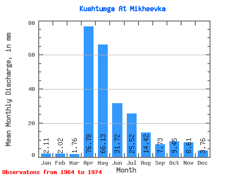
| Statistic | Jan | Feb | Mar | Apr | May | Jun | Jul | Aug | Sep | Oct | Nov | Dec | Annual |
|---|---|---|---|---|---|---|---|---|---|---|---|---|---|
| Mean | 2.11 | 2.04 | 1.75 | 76.78 | 66.11 | 31.72 | 25.52 | 14.42 | 7.72 | 9.46 | 8.61 | 3.76 | 257.26 |
| Standard Deviation | 1.17 | 2.03 | 1.32 | 29.95 | 31.91 | 27.32 | 23.77 | 16.95 | 7.43 | 6.02 | 7.33 | 1.64 | 79.07 |
| Min | 0.03 | 0.00 | 0.00 | 13.34 | 15.73 | 4.40 | 1.69 | 1.82 | 2.52 | 4.55 | 3.40 | 2.08 | 158.57 |
| Max | 3.38 | 7.11 | 4.03 | 110.35 | 118.56 | 81.03 | 71.25 | 54.34 | 23.66 | 23.27 | 27.68 | 7.16 | 395.14 |
| Coefficient of Variation | 0.56 | 1.00 | 0.75 | 0.39 | 0.48 | 0.86 | 0.93 | 1.18 | 0.96 | 0.64 | 0.85 | 0.44 | 0.31 |
 Return to R-Arctic Net Home Page