|
|
|||||||||||||||||
| Point ID: 8783 | Downloads | Plots | Site Data | Code: 12185 |
|
|
|||||||||||||||||
| Download | |
|---|---|
| Site Descriptor Information | Site Time Series Data |
| Link to all available data | |
| View: | Time Series | All |
| Units: | mm |
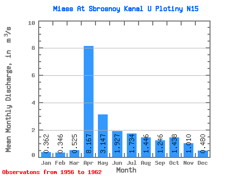
| Statistic | Jan | Feb | Mar | Apr | May | Jun | Jul | Aug | Sep | Oct | Nov | Dec | Annual |
|---|---|---|---|---|---|---|---|---|---|---|---|---|---|
| Mean | 0.36 | 0.35 | 0.53 | 8.17 | 3.15 | 1.93 | 1.73 | 1.45 | 1.25 | 1.44 | 1.01 | 0.48 | 1.94 |
| Standard Deviation | 0.16 | 0.17 | 0.33 | 1.98 | 1.66 | 1.32 | 1.78 | 1.27 | 0.75 | 1.57 | 1.04 | 0.22 | 0.41 |
| Min | 0.12 | 0.08 | 0.15 | 5.57 | 0.48 | 0.34 | 0.28 | 0.26 | 0.28 | 0.02 | 0.32 | 0.25 | 1.25 |
| Max | 0.60 | 0.55 | 0.98 | 11.00 | 5.82 | 3.99 | 4.49 | 3.71 | 2.20 | 4.72 | 3.29 | 0.84 | 2.39 |
| Coefficient of Variation | 0.45 | 0.48 | 0.63 | 0.24 | 0.53 | 0.69 | 1.02 | 0.88 | 0.60 | 1.09 | 1.03 | 0.46 | 0.21 |
 Return to R-Arctic Net Home Page