|
|
|||||||||||||||||
| Point ID: 8783 | Downloads | Plots | Site Data | Code: 12185 |
|
|
|||||||||||||||||
| Download | |
|---|---|
| Site Descriptor Information | Site Time Series Data |
| Link to all available data | |
| View: | Time Series | All |
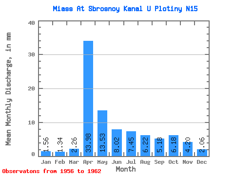
| Units: | m3/s |
| Statistic | Jan | Feb | Mar | Apr | May | Jun | Jul | Aug | Sep | Oct | Nov | Dec | Annual |
|---|---|---|---|---|---|---|---|---|---|---|---|---|---|
| Mean | 1.56 | 1.35 | 2.26 | 33.98 | 13.53 | 8.02 | 7.46 | 6.21 | 5.18 | 6.18 | 4.20 | 2.06 | 98.30 |
| Standard Deviation | 0.70 | 0.65 | 1.43 | 8.26 | 7.11 | 5.50 | 7.64 | 5.45 | 3.11 | 6.75 | 4.34 | 0.95 | 20.63 |
| Min | 0.52 | 0.33 | 0.65 | 23.17 | 2.06 | 1.42 | 1.20 | 1.12 | 1.17 | 0.10 | 1.33 | 1.07 | 63.20 |
| Max | 2.58 | 2.15 | 4.21 | 45.77 | 25.02 | 16.60 | 19.30 | 15.95 | 9.15 | 20.29 | 13.69 | 3.61 | 121.03 |
| Coefficient of Variation | 0.45 | 0.48 | 0.63 | 0.24 | 0.53 | 0.69 | 1.02 | 0.88 | 0.60 | 1.09 | 1.03 | 0.46 | 0.21 |
 Return to R-Arctic Net Home Page