|
|
|||||||||||||||||
| Point ID: 8780 | Downloads | Plots | Site Data | Code: 12165 |
|
|
|||||||||||||||||
| Download | |
|---|---|
| Site Descriptor Information | Site Time Series Data |
| Link to all available data | |
| View: | Time Series | All |
| Units: | mm |
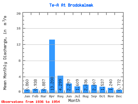
| Statistic | Jan | Feb | Mar | Apr | May | Jun | Jul | Aug | Sep | Oct | Nov | Dec | Annual |
|---|---|---|---|---|---|---|---|---|---|---|---|---|---|
| Mean | 0.86 | 0.94 | 0.89 | 13.20 | 4.30 | 2.30 | 1.61 | 2.04 | 2.01 | 1.54 | 1.24 | 0.77 | 3.18 |
| Standard Deviation | 0.74 | 0.59 | 0.69 | 10.22 | 1.98 | 1.84 | 1.21 | 1.96 | 1.77 | 1.21 | 0.88 | 0.67 | 1.99 |
| Min | 0.23 | 0.19 | 0.23 | 5.94 | 2.80 | 1.03 | 0.55 | 0.28 | 0.42 | 0.53 | 0.25 | 0.19 | 1.77 |
| Max | 1.82 | 1.64 | 2.02 | 33.40 | 7.64 | 6.42 | 3.77 | 5.57 | 5.45 | 3.95 | 2.05 | 1.68 | 6.12 |
| Coefficient of Variation | 0.86 | 0.63 | 0.77 | 0.78 | 0.46 | 0.80 | 0.75 | 0.96 | 0.88 | 0.79 | 0.71 | 0.87 | 0.63 |
 Return to R-Arctic Net Home Page