|
|
|||||||||||||||||
| Point ID: 8780 | Downloads | Plots | Site Data | Code: 12165 |
|
|
|||||||||||||||||
| Download | |
|---|---|
| Site Descriptor Information | Site Time Series Data |
| Link to all available data | |
| View: | Time Series | All |
| Units: | m3/s |
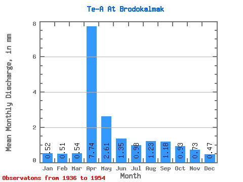
| Statistic | Jan | Feb | Mar | Apr | May | Jun | Jul | Aug | Sep | Oct | Nov | Dec | Annual |
|---|---|---|---|---|---|---|---|---|---|---|---|---|---|
| Mean | 0.52 | 0.52 | 0.54 | 7.74 | 2.60 | 1.35 | 0.97 | 1.23 | 1.18 | 0.93 | 0.73 | 0.47 | 22.72 |
| Standard Deviation | 0.45 | 0.33 | 0.42 | 6.00 | 1.20 | 1.08 | 0.73 | 1.19 | 1.04 | 0.73 | 0.51 | 0.41 | 14.24 |
| Min | 0.14 | 0.10 | 0.14 | 3.48 | 1.70 | 0.60 | 0.33 | 0.17 | 0.25 | 0.32 | 0.15 | 0.12 | 12.67 |
| Max | 1.10 | 0.91 | 1.22 | 19.59 | 4.63 | 3.77 | 2.28 | 3.38 | 3.20 | 2.39 | 1.20 | 1.02 | 43.68 |
| Coefficient of Variation | 0.86 | 0.63 | 0.77 | 0.78 | 0.46 | 0.80 | 0.75 | 0.96 | 0.88 | 0.79 | 0.71 | 0.87 | 0.63 |
 Return to R-Arctic Net Home Page