|
|
|||||||||||||||||
| Point ID: 8764 | Downloads | Plots | Site Data | Code: 12045 |
|
|
|||||||||||||||||
| Download | |
|---|---|
| Site Descriptor Information | Site Time Series Data |
| Link to all available data | |
| View: | Time Series | All |
| Units: | mm |
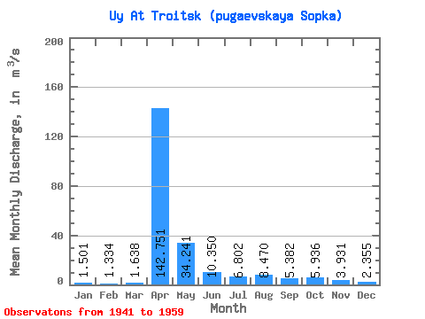
| Statistic | Jan | Feb | Mar | Apr | May | Jun | Jul | Aug | Sep | Oct | Nov | Dec | Annual |
|---|---|---|---|---|---|---|---|---|---|---|---|---|---|
| Mean | 1.50 | 1.33 | 1.64 | 142.75 | 34.24 | 10.35 | 6.80 | 8.47 | 5.38 | 5.94 | 3.93 | 2.35 | 17.62 |
| Standard Deviation | 1.00 | 1.05 | 1.20 | 123.30 | 55.58 | 8.18 | 5.15 | 9.82 | 4.23 | 4.11 | 3.13 | 2.08 | 12.89 |
| Min | 0.15 | 0.13 | 0.22 | 8.72 | 6.55 | 2.46 | 2.04 | 1.15 | 1.33 | 1.60 | 1.13 | 0.33 | 3.53 |
| Max | 4.83 | 4.67 | 4.39 | 435.00 | 255.00 | 38.60 | 22.50 | 38.70 | 18.70 | 16.40 | 15.00 | 9.72 | 49.95 |
| Coefficient of Variation | 0.67 | 0.79 | 0.73 | 0.86 | 1.62 | 0.79 | 0.76 | 1.16 | 0.79 | 0.69 | 0.80 | 0.88 | 0.73 |
 Return to R-Arctic Net Home Page