|
|
|||||||||||||||||
| Point ID: 8764 | Downloads | Plots | Site Data | Code: 12045 |
|
|
|||||||||||||||||
| Download | |
|---|---|
| Site Descriptor Information | Site Time Series Data |
| Link to all available data | |
| View: | Time Series | All |
| Units: | m3/s |
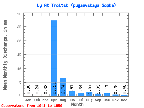
| Statistic | Jan | Feb | Mar | Apr | May | Jun | Jul | Aug | Sep | Oct | Nov | Dec | Annual |
|---|---|---|---|---|---|---|---|---|---|---|---|---|---|
| Mean | 0.30 | 0.24 | 0.32 | 27.21 | 6.74 | 1.97 | 1.34 | 1.67 | 1.03 | 1.17 | 0.75 | 0.46 | 40.88 |
| Standard Deviation | 0.20 | 0.19 | 0.24 | 23.50 | 10.94 | 1.56 | 1.01 | 1.93 | 0.81 | 0.81 | 0.60 | 0.41 | 29.90 |
| Min | 0.03 | 0.02 | 0.04 | 1.66 | 1.29 | 0.47 | 0.40 | 0.23 | 0.25 | 0.32 | 0.21 | 0.07 | 8.19 |
| Max | 0.95 | 0.84 | 0.86 | 82.91 | 50.21 | 7.36 | 4.43 | 7.62 | 3.56 | 3.23 | 2.86 | 1.91 | 115.91 |
| Coefficient of Variation | 0.67 | 0.79 | 0.73 | 0.86 | 1.62 | 0.79 | 0.76 | 1.16 | 0.79 | 0.69 | 0.80 | 0.88 | 0.73 |
 Return to R-Arctic Net Home Page