|
|
|||||||||||||||||
| Point ID: 874 | Downloads | Plots | Site Data | Code: 07EF001 |
|
|
|||||||||||||||||
| Download | |
|---|---|
| Site Descriptor Information | Site Time Series Data |
| Link to all available data | |
| View: | Time Series | All |
| Units: | mm |
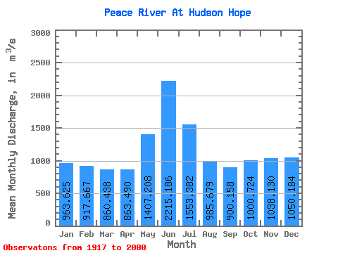
| Statistic | Jan | Feb | Mar | Apr | May | Jun | Jul | Aug | Sep | Oct | Nov | Dec | Annual |
|---|---|---|---|---|---|---|---|---|---|---|---|---|---|
| Mean | 963.62 | 917.67 | 860.44 | 863.49 | 1407.21 | 2215.19 | 1553.38 | 985.68 | 900.16 | 1000.72 | 1038.13 | 1050.18 | 1103.64 |
| Standard Deviation | 577.28 | 582.78 | 552.61 | 455.34 | 875.63 | 1803.42 | 1046.38 | 444.82 | 299.13 | 319.94 | 452.93 | 584.80 | 254.79 |
| Min | 173.00 | 153.00 | 144.00 | 164.00 | 109.00 | 81.60 | 67.80 | 59.70 | 155.00 | 205.00 | 254.00 | 191.00 | 162.34 |
| Max | 1860.00 | 1800.00 | 1810.00 | 1840.00 | 3720.00 | 6800.00 | 4700.00 | 2530.00 | 1650.00 | 1610.00 | 1740.00 | 1860.00 | 1717.83 |
| Coefficient of Variation | 0.60 | 0.64 | 0.64 | 0.53 | 0.62 | 0.81 | 0.67 | 0.45 | 0.33 | 0.32 | 0.44 | 0.56 | 0.23 |
 Return to R-Arctic Net Home Page