|
|
|||||||||||||||||
| Point ID: 874 | Downloads | Plots | Site Data | Code: 07EF001 |
|
|
|||||||||||||||||
| Download | |
|---|---|
| Site Descriptor Information | Site Time Series Data |
| Link to all available data | |
| View: | Time Series | All |
| Units: | m3/s |
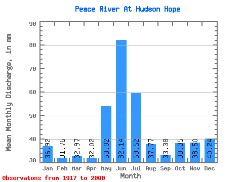
| Statistic | Jan | Feb | Mar | Apr | May | Jun | Jul | Aug | Sep | Oct | Nov | Dec | Annual |
|---|---|---|---|---|---|---|---|---|---|---|---|---|---|
| Mean | 36.92 | 32.03 | 32.97 | 32.02 | 53.91 | 82.14 | 59.51 | 37.76 | 33.38 | 38.34 | 38.49 | 40.23 | 498.30 |
| Standard Deviation | 22.12 | 20.34 | 21.17 | 16.89 | 33.55 | 66.87 | 40.09 | 17.04 | 11.09 | 12.26 | 16.80 | 22.41 | 115.04 |
| Min | 6.63 | 5.34 | 5.52 | 6.08 | 4.18 | 3.03 | 2.60 | 2.29 | 5.75 | 7.85 | 9.42 | 7.32 | 73.30 |
| Max | 71.26 | 62.83 | 69.34 | 68.23 | 142.52 | 252.16 | 180.07 | 96.93 | 61.19 | 61.68 | 64.52 | 71.26 | 775.61 |
| Coefficient of Variation | 0.60 | 0.64 | 0.64 | 0.53 | 0.62 | 0.81 | 0.67 | 0.45 | 0.33 | 0.32 | 0.44 | 0.56 | 0.23 |
 Return to R-Arctic Net Home Page