|
|
|||||||||||||||||
| Point ID: 8715 | Downloads | Plots | Site Data | Code: 12457 |
|
|
|||||||||||||||||
| Download | |
|---|---|
| Site Descriptor Information | Site Time Series Data |
| Link to all available data | |
| View: | Time Series | All |
| Units: | mm |
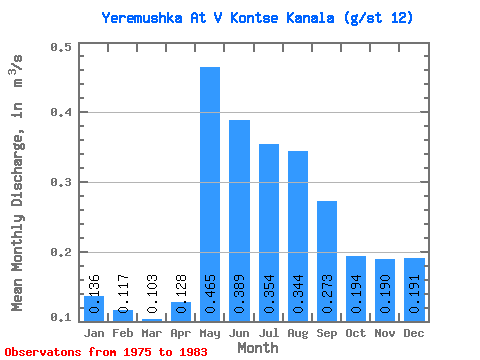
| Statistic | Jan | Feb | Mar | Apr | May | Jun | Jul | Aug | Sep | Oct | Nov | Dec | Annual |
|---|---|---|---|---|---|---|---|---|---|---|---|---|---|
| Mean | 0.14 | 0.12 | 0.10 | 0.13 | 0.47 | 0.39 | 0.35 | 0.34 | 0.27 | 0.19 | 0.19 | 0.19 | 0.25 |
| Standard Deviation | 0.21 | 0.18 | 0.14 | 0.14 | 0.42 | 0.44 | 0.42 | 0.38 | 0.29 | 0.17 | 0.21 | 0.22 | 0.20 |
| Min | 0.01 | 0.01 | 0.01 | 0.04 | 0.04 | 0.04 | 0.05 | 0.04 | 0.04 | 0.04 | 0.04 | 0.02 | 0.04 |
| Max | 0.57 | 0.47 | 0.40 | 0.43 | 1.27 | 1.39 | 1.23 | 0.95 | 0.88 | 0.60 | 0.60 | 0.60 | 0.47 |
| Coefficient of Variation | 1.54 | 1.51 | 1.41 | 1.06 | 0.90 | 1.14 | 1.18 | 1.10 | 1.06 | 0.91 | 1.09 | 1.17 | 0.79 |
 Return to R-Arctic Net Home Page