|
|
|||||||||||||||||
| Point ID: 8715 | Downloads | Plots | Site Data | Code: 12457 |
|
|
|||||||||||||||||
| Download | |
|---|---|
| Site Descriptor Information | Site Time Series Data |
| Link to all available data | |
| View: | Time Series | All |
| Units: | m3/s |
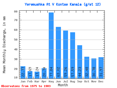
| Statistic | Jan | Feb | Mar | Apr | May | Jun | Jul | Aug | Sep | Oct | Nov | Dec | Annual |
|---|---|---|---|---|---|---|---|---|---|---|---|---|---|
| Mean | 3.61 | 2.82 | 2.73 | 3.28 | 12.34 | 9.99 | 9.39 | 9.11 | 7.00 | 5.13 | 4.88 | 5.08 | 77.57 |
| Standard Deviation | 5.55 | 4.26 | 3.85 | 3.47 | 11.07 | 11.38 | 11.10 | 10.01 | 7.40 | 4.65 | 5.33 | 5.93 | 61.03 |
| Min | 0.15 | 0.14 | 0.28 | 1.03 | 1.06 | 1.04 | 1.35 | 1.13 | 1.04 | 1.03 | 0.89 | 0.64 | 11.46 |
| Max | 15.13 | 11.37 | 10.61 | 11.05 | 33.67 | 35.67 | 32.61 | 25.19 | 22.58 | 15.91 | 15.40 | 15.91 | 145.62 |
| Coefficient of Variation | 1.54 | 1.51 | 1.41 | 1.06 | 0.90 | 1.14 | 1.18 | 1.10 | 1.06 | 0.91 | 1.09 | 1.17 | 0.79 |
 Return to R-Arctic Net Home Page