|
|
|||||||||||||||||
| Point ID: 8714 | Downloads | Plots | Site Data | Code: 12447 |
|
|
|||||||||||||||||
| Download | |
|---|---|
| Site Descriptor Information | Site Time Series Data |
| Link to all available data | |
| View: | Time Series | All |
| Units: | mm |
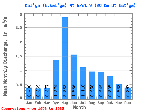
| Statistic | Jan | Feb | Mar | Apr | May | Jun | Jul | Aug | Sep | Oct | Nov | Dec | Annual |
|---|---|---|---|---|---|---|---|---|---|---|---|---|---|
| Mean | 0.40 | 0.37 | 0.38 | 1.37 | 2.85 | 1.56 | 1.12 | 0.96 | 0.95 | 0.81 | 0.53 | 0.40 | 1.01 |
| Standard Deviation | 0.20 | 0.21 | 0.19 | 0.86 | 1.80 | 1.13 | 1.23 | 0.80 | 0.56 | 0.50 | 0.23 | 0.16 | 0.36 |
| Min | 0.10 | 0.10 | 0.10 | 0.22 | 0.44 | 0.00 | 0.00 | 0.00 | 0.26 | 0.29 | 0.21 | 0.15 | 0.55 |
| Max | 0.80 | 0.90 | 0.70 | 3.49 | 7.55 | 4.55 | 6.85 | 3.72 | 2.82 | 2.61 | 1.15 | 0.67 | 2.04 |
| Coefficient of Variation | 0.49 | 0.57 | 0.51 | 0.63 | 0.63 | 0.73 | 1.11 | 0.83 | 0.58 | 0.62 | 0.44 | 0.40 | 0.35 |
 Return to R-Arctic Net Home Page