|
|
|||||||||||||||||
| Point ID: 8714 | Downloads | Plots | Site Data | Code: 12447 |
|
|
|||||||||||||||||
| Download | |
|---|---|
| Site Descriptor Information | Site Time Series Data |
| Link to all available data | |
| View: | Time Series | All |
| Units: | m3/s |
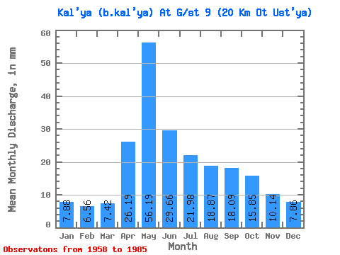
| Statistic | Jan | Feb | Mar | Apr | May | Jun | Jul | Aug | Sep | Oct | Nov | Dec | Annual |
|---|---|---|---|---|---|---|---|---|---|---|---|---|---|
| Mean | 7.88 | 6.62 | 7.42 | 26.18 | 56.19 | 29.65 | 21.97 | 18.87 | 18.09 | 15.85 | 10.13 | 7.86 | 234.36 |
| Standard Deviation | 3.87 | 3.78 | 3.81 | 16.39 | 35.47 | 21.61 | 24.30 | 15.77 | 10.58 | 9.89 | 4.48 | 3.15 | 82.51 |
| Min | 1.97 | 1.79 | 1.97 | 4.19 | 8.66 | 0.00 | 0.00 | 0.00 | 4.96 | 5.71 | 4.00 | 2.95 | 126.47 |
| Max | 15.75 | 16.15 | 13.78 | 66.52 | 148.67 | 86.72 | 134.88 | 73.26 | 53.75 | 51.39 | 21.92 | 13.21 | 472.48 |
| Coefficient of Variation | 0.49 | 0.57 | 0.51 | 0.63 | 0.63 | 0.73 | 1.11 | 0.83 | 0.58 | 0.62 | 0.44 | 0.40 | 0.35 |
 Return to R-Arctic Net Home Page