|
|
|||||||||||||||||
| Point ID: 8713 | Downloads | Plots | Site Data | Code: 12445 |
|
|
|||||||||||||||||
| Download | |
|---|---|
| Site Descriptor Information | Site Time Series Data |
| Link to all available data | |
| View: | Time Series | All |
| Units: | mm |
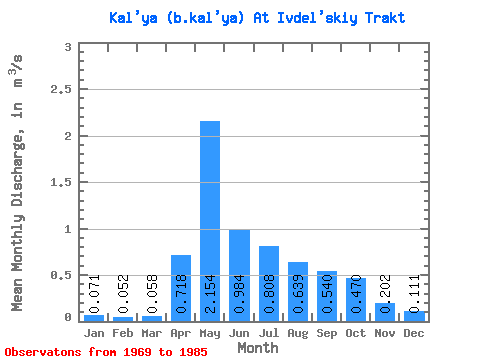
| Statistic | Jan | Feb | Mar | Apr | May | Jun | Jul | Aug | Sep | Oct | Nov | Dec | Annual |
|---|---|---|---|---|---|---|---|---|---|---|---|---|---|
| Mean | 0.07 | 0.05 | 0.06 | 0.72 | 2.15 | 0.98 | 0.81 | 0.64 | 0.54 | 0.47 | 0.20 | 0.11 | 0.55 |
| Standard Deviation | 0.03 | 0.02 | 0.02 | 0.57 | 1.42 | 0.77 | 0.97 | 0.68 | 0.49 | 0.38 | 0.11 | 0.05 | 0.24 |
| Min | 0.02 | 0.02 | 0.03 | 0.10 | 0.29 | 0.16 | 0.07 | 0.09 | 0.08 | 0.07 | 0.07 | 0.06 | 0.20 |
| Max | 0.14 | 0.09 | 0.11 | 1.93 | 5.15 | 2.98 | 4.07 | 2.83 | 1.96 | 1.42 | 0.40 | 0.23 | 0.98 |
| Coefficient of Variation | 0.43 | 0.37 | 0.41 | 0.80 | 0.66 | 0.78 | 1.20 | 1.06 | 0.90 | 0.81 | 0.55 | 0.41 | 0.44 |
 Return to R-Arctic Net Home Page