|
|
|||||||||||||||||
| Point ID: 8713 | Downloads | Plots | Site Data | Code: 12445 |
|
|
|||||||||||||||||
| Download | |
|---|---|
| Site Descriptor Information | Site Time Series Data |
| Link to all available data | |
| View: | Time Series | All |
| Units: | m3/s |
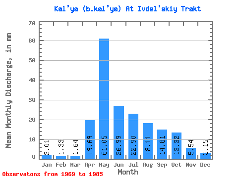
| Statistic | Jan | Feb | Mar | Apr | May | Jun | Jul | Aug | Sep | Oct | Nov | Dec | Annual |
|---|---|---|---|---|---|---|---|---|---|---|---|---|---|
| Mean | 2.01 | 1.35 | 1.66 | 19.70 | 61.04 | 26.99 | 22.89 | 18.11 | 14.81 | 13.31 | 5.55 | 3.16 | 182.10 |
| Standard Deviation | 0.87 | 0.50 | 0.67 | 15.66 | 40.34 | 21.10 | 27.45 | 19.20 | 13.32 | 10.79 | 3.06 | 1.29 | 80.10 |
| Min | 0.58 | 0.53 | 0.74 | 2.74 | 8.23 | 4.41 | 1.87 | 2.55 | 2.19 | 2.07 | 1.92 | 1.59 | 65.80 |
| Max | 3.98 | 2.34 | 3.13 | 52.94 | 145.94 | 81.75 | 115.37 | 80.20 | 53.78 | 40.26 | 10.97 | 6.52 | 328.25 |
| Coefficient of Variation | 0.43 | 0.37 | 0.41 | 0.80 | 0.66 | 0.78 | 1.20 | 1.06 | 0.90 | 0.81 | 0.55 | 0.41 | 0.44 |
 Return to R-Arctic Net Home Page