|
|
|||||||||||||||||
| Point ID: 8690 | Downloads | Plots | Site Data | Code: 11607 |
|
|
|||||||||||||||||
| Download | |
|---|---|
| Site Descriptor Information | Site Time Series Data |
| Link to all available data | |
| View: | Time Series | All |
| Units: | mm |
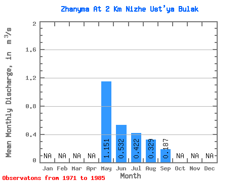
| Statistic | Jan | Feb | Mar | Apr | May | Jun | Jul | Aug | Sep | Oct | Nov | Dec | Annual |
|---|---|---|---|---|---|---|---|---|---|---|---|---|---|
| Mean | 1.15 | 0.53 | 0.42 | 0.33 | 0.19 | ||||||||
| Standard Deviation | 1.03 | 0.27 | 0.35 | 0.20 | 0.12 | ||||||||
| Min | 0.09 | 0.20 | 0.09 | 0.09 | 0.10 | ||||||||
| Max | 3.38 | 1.12 | 1.37 | 0.70 | 0.32 | ||||||||
| Coefficient of Variation | 0.89 | 0.51 | 0.82 | 0.62 | 0.63 |
 Return to R-Arctic Net Home Page