|
|
|||||||||||||||||
| Point ID: 8690 | Downloads | Plots | Site Data | Code: 11607 |
|
|
|||||||||||||||||
| Download | |
|---|---|
| Site Descriptor Information | Site Time Series Data |
| Link to all available data | |
| View: | Time Series | All |
| Units: | m3/s |
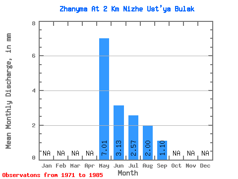
| Statistic | Jan | Feb | Mar | Apr | May | Jun | Jul | Aug | Sep | Oct | Nov | Dec | Annual |
|---|---|---|---|---|---|---|---|---|---|---|---|---|---|
| Mean | 7.00 | 3.13 | 2.57 | 2.00 | 1.10 | ||||||||
| Standard Deviation | 6.26 | 1.58 | 2.12 | 1.23 | 0.69 | ||||||||
| Min | 0.52 | 1.18 | 0.56 | 0.52 | 0.59 | ||||||||
| Max | 20.57 | 6.60 | 8.34 | 4.26 | 1.89 | ||||||||
| Coefficient of Variation | 0.89 | 0.51 | 0.82 | 0.62 | 0.63 |
 Return to R-Arctic Net Home Page