|
|
|||||||||||||||||
| Point ID: 8684 | Downloads | Plots | Site Data | Code: 11601 |
|
|
|||||||||||||||||
| Download | |
|---|---|
| Site Descriptor Information | Site Time Series Data |
| Link to all available data | |
| View: | Time Series | All |
| Units: | mm |
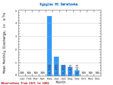
| Statistic | Jan | Feb | Mar | Apr | May | Jun | Jul | Aug | Sep | Oct | Nov | Dec | Annual |
|---|---|---|---|---|---|---|---|---|---|---|---|---|---|
| Mean | 4.55 | 1.46 | 0.83 | 0.68 | 0.42 | ||||||||
| Standard Deviation | 4.83 | 1.32 | 0.88 | 0.67 | 0.35 | ||||||||
| Min | 0.55 | 0.12 | 0.13 | 0.12 | 0.16 | ||||||||
| Max | 14.90 | 4.22 | 3.08 | 2.59 | 1.02 | ||||||||
| Coefficient of Variation | 1.06 | 0.91 | 1.05 | 0.98 | 0.82 |
 Return to R-Arctic Net Home Page