|
|
|||||||||||||||||
| Point ID: 8684 | Downloads | Plots | Site Data | Code: 11601 |
|
|
|||||||||||||||||
| Download | |
|---|---|
| Site Descriptor Information | Site Time Series Data |
| Link to all available data | |
| View: | Time Series | All |
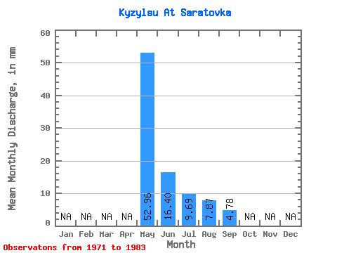
| Units: | m3/s |
| Statistic | Jan | Feb | Mar | Apr | May | Jun | Jul | Aug | Sep | Oct | Nov | Dec | Annual |
|---|---|---|---|---|---|---|---|---|---|---|---|---|---|
| Mean | 52.95 | 16.40 | 9.68 | 7.87 | 4.78 | ||||||||
| Standard Deviation | 56.22 | 14.89 | 10.19 | 7.75 | 3.92 | ||||||||
| Min | 6.40 | 1.35 | 1.51 | 1.40 | 1.80 | ||||||||
| Max | 173.49 | 47.56 | 35.86 | 30.16 | 11.49 | ||||||||
| Coefficient of Variation | 1.06 | 0.91 | 1.05 | 0.98 | 0.82 |
 Return to R-Arctic Net Home Page