|
|
|||||||||||||||||
| Point ID: 8683 | Downloads | Plots | Site Data | Code: 11599 |
|
|
|||||||||||||||||
| Download | |
|---|---|
| Site Descriptor Information | Site Time Series Data |
| Link to all available data | |
| View: | Time Series | All |
| Units: | mm |
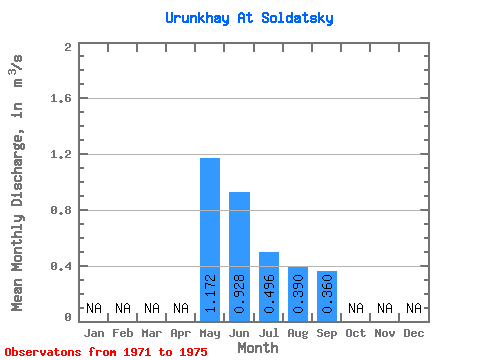
| Statistic | Jan | Feb | Mar | Apr | May | Jun | Jul | Aug | Sep | Oct | Nov | Dec | Annual |
|---|---|---|---|---|---|---|---|---|---|---|---|---|---|
| Mean | 1.17 | 0.93 | 0.50 | 0.39 | 0.36 | ||||||||
| Standard Deviation | 0.41 | 0.43 | 0.20 | 0.16 | 0.11 | ||||||||
| Min | 0.70 | 0.39 | 0.20 | 0.13 | 0.21 | ||||||||
| Max | 1.66 | 1.35 | 0.65 | 0.52 | 0.49 | ||||||||
| Coefficient of Variation | 0.35 | 0.46 | 0.41 | 0.42 | 0.31 |
 Return to R-Arctic Net Home Page