|
|
|||||||||||||||||
| Point ID: 8683 | Downloads | Plots | Site Data | Code: 11599 |
|
|
|||||||||||||||||
| Download | |
|---|---|
| Site Descriptor Information | Site Time Series Data |
| Link to all available data | |
| View: | Time Series | All |
| Units: | m3/s |
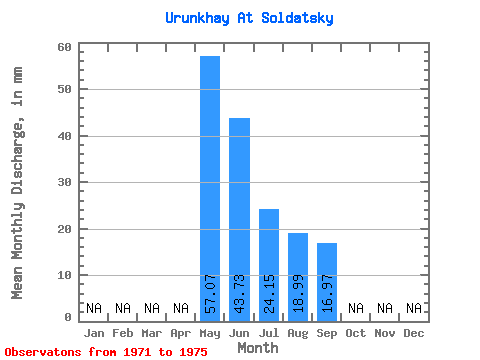
| Statistic | Jan | Feb | Mar | Apr | May | Jun | Jul | Aug | Sep | Oct | Nov | Dec | Annual |
|---|---|---|---|---|---|---|---|---|---|---|---|---|---|
| Mean | 57.07 | 43.73 | 24.15 | 18.99 | 16.97 | ||||||||
| Standard Deviation | 19.74 | 20.19 | 10.01 | 7.93 | 5.18 | ||||||||
| Min | 34.08 | 18.38 | 9.74 | 6.33 | 9.90 | ||||||||
| Max | 80.83 | 63.62 | 31.65 | 25.32 | 23.09 | ||||||||
| Coefficient of Variation | 0.35 | 0.46 | 0.41 | 0.42 | 0.31 |
 Return to R-Arctic Net Home Page