|
|
|||||||||||||||||
| Point ID: 8679 | Downloads | Plots | Site Data | Code: 11595 |
|
|
|||||||||||||||||
| Download | |
|---|---|
| Site Descriptor Information | Site Time Series Data |
| Link to all available data | |
| View: | Time Series | All |
| Units: | mm |
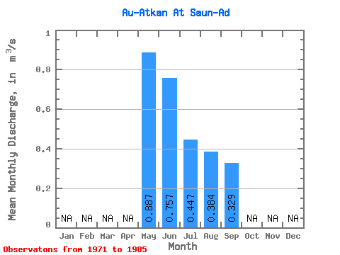
| Statistic | Jan | Feb | Mar | Apr | May | Jun | Jul | Aug | Sep | Oct | Nov | Dec | Annual |
|---|---|---|---|---|---|---|---|---|---|---|---|---|---|
| Mean | 0.89 | 0.76 | 0.45 | 0.38 | 0.33 | ||||||||
| Standard Deviation | 0.29 | 0.23 | 0.19 | 0.17 | 0.15 | ||||||||
| Min | 0.33 | 0.35 | 0.27 | 0.19 | 0.13 | ||||||||
| Max | 1.54 | 1.19 | 0.94 | 0.70 | 0.71 | ||||||||
| Coefficient of Variation | 0.33 | 0.30 | 0.43 | 0.44 | 0.46 |
 Return to R-Arctic Net Home Page