|
|
|||||||||||||||||
| Point ID: 8679 | Downloads | Plots | Site Data | Code: 11595 |
|
|
|||||||||||||||||
| Download | |
|---|---|
| Site Descriptor Information | Site Time Series Data |
| Link to all available data | |
| View: | Time Series | All |
| Units: | m3/s |
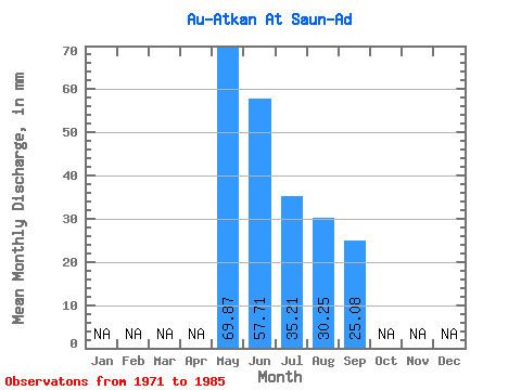
| Statistic | Jan | Feb | Mar | Apr | May | Jun | Jul | Aug | Sep | Oct | Nov | Dec | Annual |
|---|---|---|---|---|---|---|---|---|---|---|---|---|---|
| Mean | 69.84 | 57.69 | 35.23 | 30.25 | 25.11 | ||||||||
| Standard Deviation | 23.21 | 17.59 | 15.20 | 13.18 | 11.53 | ||||||||
| Min | 25.99 | 26.68 | 21.27 | 14.96 | 9.91 | ||||||||
| Max | 121.30 | 90.72 | 74.04 | 55.13 | 54.13 | ||||||||
| Coefficient of Variation | 0.33 | 0.30 | 0.43 | 0.44 | 0.46 |
 Return to R-Arctic Net Home Page