|
|
|||||||||||||||||
| Point ID: 8671 | Downloads | Plots | Site Data | Code: 11551 |
|
|
|||||||||||||||||
| Download | |
|---|---|
| Site Descriptor Information | Site Time Series Data |
| Link to all available data | |
| View: | Time Series | All |
| Units: | mm |
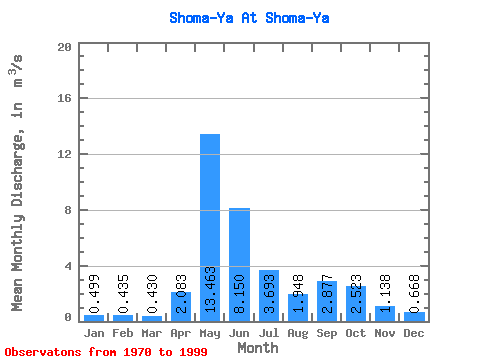
| Statistic | Jan | Feb | Mar | Apr | May | Jun | Jul | Aug | Sep | Oct | Nov | Dec | Annual |
|---|---|---|---|---|---|---|---|---|---|---|---|---|---|
| Mean | 0.50 | 0.43 | 0.43 | 2.08 | 13.46 | 8.15 | 3.69 | 1.95 | 2.88 | 2.52 | 1.14 | 0.67 | 3.18 |
| Standard Deviation | 0.13 | 0.13 | 0.13 | 3.01 | 5.47 | 6.70 | 2.52 | 0.98 | 2.43 | 1.29 | 0.45 | 0.15 | 0.67 |
| Min | 0.28 | 0.14 | 0.13 | 0.12 | 2.80 | 1.61 | 0.82 | 0.97 | 0.96 | 0.73 | 0.46 | 0.36 | 1.75 |
| Max | 0.75 | 0.68 | 0.71 | 11.50 | 23.80 | 28.20 | 8.49 | 4.39 | 12.50 | 5.50 | 2.67 | 0.96 | 4.40 |
| Coefficient of Variation | 0.25 | 0.30 | 0.31 | 1.44 | 0.41 | 0.82 | 0.68 | 0.51 | 0.84 | 0.51 | 0.39 | 0.23 | 0.21 |
 Return to R-Arctic Net Home Page