|
|
|||||||||||||||||
| Point ID: 8671 | Downloads | Plots | Site Data | Code: 11551 |
|
|
|||||||||||||||||
| Download | |
|---|---|
| Site Descriptor Information | Site Time Series Data |
| Link to all available data | |
| View: | Time Series | All |
| Units: | m3/s |
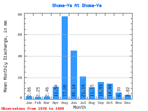
| Statistic | Jan | Feb | Mar | Apr | May | Jun | Jul | Aug | Sep | Oct | Nov | Dec | Annual |
|---|---|---|---|---|---|---|---|---|---|---|---|---|---|
| Mean | 2.86 | 2.27 | 2.46 | 11.54 | 77.04 | 45.14 | 21.13 | 11.15 | 15.93 | 14.44 | 6.30 | 3.82 | 214.19 |
| Standard Deviation | 0.72 | 0.68 | 0.77 | 16.66 | 31.33 | 37.12 | 14.43 | 5.63 | 13.46 | 7.40 | 2.48 | 0.86 | 45.02 |
| Min | 1.60 | 0.73 | 0.74 | 0.67 | 16.02 | 8.92 | 4.69 | 5.55 | 5.32 | 4.18 | 2.55 | 2.06 | 117.68 |
| Max | 4.29 | 3.54 | 4.06 | 63.69 | 136.19 | 156.19 | 48.58 | 25.12 | 69.23 | 31.47 | 14.79 | 5.49 | 296.66 |
| Coefficient of Variation | 0.25 | 0.30 | 0.31 | 1.44 | 0.41 | 0.82 | 0.68 | 0.51 | 0.84 | 0.51 | 0.39 | 0.23 | 0.21 |
 Return to R-Arctic Net Home Page