|
|
|||||||||||||||||
| Point ID: 8651 | Downloads | Plots | Site Data | Code: 11421 |
|
|
|||||||||||||||||
| Download | |
|---|---|
| Site Descriptor Information | Site Time Series Data |
| Link to all available data | |
| View: | Time Series | All |
| Units: | mm |
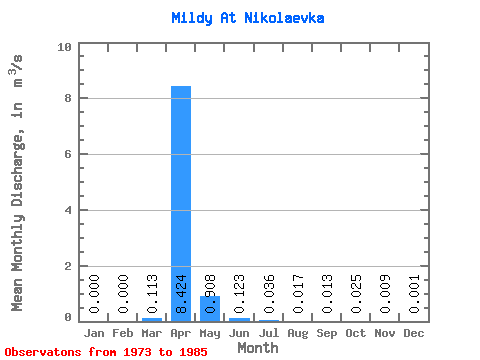
| Statistic | Jan | Feb | Mar | Apr | May | Jun | Jul | Aug | Sep | Oct | Nov | Dec | Annual |
|---|---|---|---|---|---|---|---|---|---|---|---|---|---|
| Mean | 0.00 | 0.00 | 0.11 | 8.42 | 0.91 | 0.12 | 0.04 | 0.02 | 0.01 | 0.03 | 0.01 | 0.00 | 0.80 |
| Standard Deviation | 0.00 | 0.00 | 0.28 | 7.58 | 0.71 | 0.09 | 0.05 | 0.03 | 0.03 | 0.03 | 0.01 | 0.00 | 0.65 |
| Min | 0.00 | 0.00 | 0.00 | 0.46 | 0.03 | 0.01 | 0.00 | 0.00 | 0.00 | 0.00 | 0.00 | 0.00 | 0.05 |
| Max | 0.00 | 0.00 | 0.97 | 29.00 | 2.35 | 0.29 | 0.16 | 0.08 | 0.07 | 0.08 | 0.04 | 0.01 | 2.51 |
| Coefficient of Variation | 2.49 | 0.90 | 0.78 | 0.73 | 1.36 | 1.71 | 1.93 | 1.13 | 1.62 | 2.75 | 0.81 |
 Return to R-Arctic Net Home Page