|
|
|||||||||||||||||
| Point ID: 8651 | Downloads | Plots | Site Data | Code: 11421 |
|
|
|||||||||||||||||
| Download | |
|---|---|
| Site Descriptor Information | Site Time Series Data |
| Link to all available data | |
| View: | Time Series | All |
| Units: | m3/s |
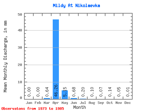
| Statistic | Jan | Feb | Mar | Apr | May | Jun | Jul | Aug | Sep | Oct | Nov | Dec | Annual |
|---|---|---|---|---|---|---|---|---|---|---|---|---|---|
| Mean | 0.00 | 0.00 | 0.64 | 46.26 | 5.15 | 0.68 | 0.20 | 0.10 | 0.07 | 0.14 | 0.05 | 0.01 | 53.48 |
| Standard Deviation | 0.00 | 0.00 | 1.59 | 41.61 | 4.00 | 0.50 | 0.28 | 0.16 | 0.14 | 0.16 | 0.08 | 0.02 | 43.62 |
| Min | 0.00 | 0.00 | 0.00 | 2.53 | 0.18 | 0.03 | 0.00 | 0.00 | 0.00 | 0.00 | 0.00 | 0.00 | 3.49 |
| Max | 0.00 | 0.00 | 5.50 | 159.25 | 13.33 | 1.59 | 0.91 | 0.45 | 0.39 | 0.43 | 0.24 | 0.08 | 168.04 |
| Coefficient of Variation | 2.49 | 0.90 | 0.78 | 0.73 | 1.36 | 1.71 | 1.93 | 1.13 | 1.62 | 2.75 | 0.81 |
 Return to R-Arctic Net Home Page