|
|
|||||||||||||||||
| Point ID: 8650 | Downloads | Plots | Site Data | Code: 11420 |
|
|
|||||||||||||||||
| Download | |
|---|---|
| Site Descriptor Information | Site Time Series Data |
| Link to all available data | |
| View: | Time Series | All |
| Units: | mm |
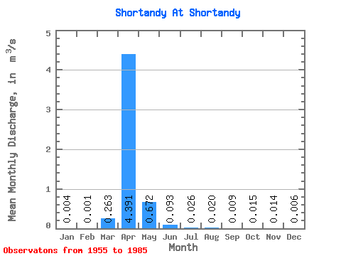
| Statistic | Jan | Feb | Mar | Apr | May | Jun | Jul | Aug | Sep | Oct | Nov | Dec | Annual |
|---|---|---|---|---|---|---|---|---|---|---|---|---|---|
| Mean | 0.00 | 0.00 | 0.26 | 4.39 | 0.67 | 0.09 | 0.03 | 0.02 | 0.01 | 0.01 | 0.01 | 0.01 | 0.50 |
| Standard Deviation | 0.01 | 0.00 | 0.70 | 4.12 | 0.91 | 0.14 | 0.04 | 0.07 | 0.02 | 0.04 | 0.03 | 0.01 | 0.43 |
| Min | 0.00 | 0.00 | 0.00 | 0.09 | 0.00 | 0.00 | 0.00 | 0.00 | 0.00 | 0.00 | 0.00 | 0.00 | 0.01 |
| Max | 0.05 | 0.02 | 3.43 | 15.30 | 4.01 | 0.53 | 0.18 | 0.35 | 0.11 | 0.18 | 0.11 | 0.05 | 1.64 |
| Coefficient of Variation | 2.64 | 5.14 | 2.65 | 0.94 | 1.35 | 1.53 | 1.71 | 3.37 | 2.63 | 2.59 | 2.04 | 2.45 | 0.86 |
 Return to R-Arctic Net Home Page