|
|
|||||||||||||||||
| Point ID: 8650 | Downloads | Plots | Site Data | Code: 11420 |
|
|
|||||||||||||||||
| Download | |
|---|---|
| Site Descriptor Information | Site Time Series Data |
| Link to all available data | |
| View: | Time Series | All |
| Units: | m3/s |
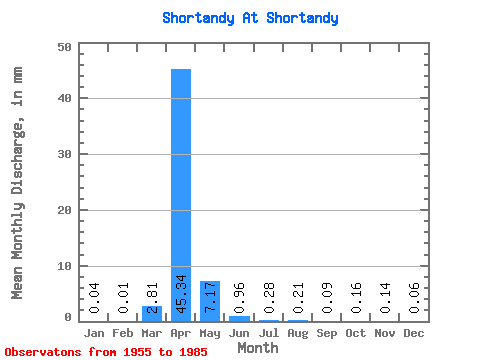
| Statistic | Jan | Feb | Mar | Apr | May | Jun | Jul | Aug | Sep | Oct | Nov | Dec | Annual |
|---|---|---|---|---|---|---|---|---|---|---|---|---|---|
| Mean | 0.04 | 0.01 | 2.81 | 45.34 | 7.17 | 0.96 | 0.28 | 0.21 | 0.09 | 0.16 | 0.15 | 0.06 | 62.34 |
| Standard Deviation | 0.11 | 0.04 | 7.43 | 42.60 | 9.70 | 1.47 | 0.47 | 0.71 | 0.24 | 0.41 | 0.30 | 0.14 | 53.53 |
| Min | 0.00 | 0.00 | 0.00 | 0.90 | 0.00 | 0.00 | 0.00 | 0.00 | 0.00 | 0.00 | 0.00 | 0.00 | 0.91 |
| Max | 0.50 | 0.20 | 36.60 | 158.00 | 42.78 | 5.47 | 1.93 | 3.74 | 1.14 | 1.93 | 1.14 | 0.56 | 206.34 |
| Coefficient of Variation | 2.64 | 5.14 | 2.65 | 0.94 | 1.35 | 1.53 | 1.71 | 3.37 | 2.63 | 2.59 | 2.04 | 2.45 | 0.86 |
 Return to R-Arctic Net Home Page