|
|
|||||||||||||||||
| Point ID: 8645 | Downloads | Plots | Site Data | Code: 11393 |
|
|
|||||||||||||||||
| Download | |
|---|---|
| Site Descriptor Information | Site Time Series Data |
| Link to all available data | |
| View: | Time Series | All |
| Units: | mm |
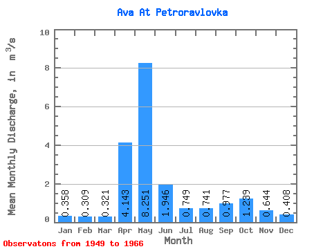
| Statistic | Jan | Feb | Mar | Apr | May | Jun | Jul | Aug | Sep | Oct | Nov | Dec | Annual |
|---|---|---|---|---|---|---|---|---|---|---|---|---|---|
| Mean | 0.36 | 0.31 | 0.32 | 4.14 | 8.25 | 1.95 | 0.75 | 0.74 | 0.98 | 1.24 | 0.64 | 0.41 | 1.60 |
| Standard Deviation | 0.14 | 0.17 | 0.11 | 2.62 | 4.33 | 1.67 | 0.49 | 0.74 | 0.80 | 0.77 | 0.29 | 0.16 | 0.47 |
| Min | 0.14 | 0.13 | 0.14 | 0.58 | 3.57 | 0.62 | 0.27 | 0.20 | 0.31 | 0.41 | 0.29 | 0.17 | 0.84 |
| Max | 0.76 | 0.80 | 0.50 | 9.71 | 19.40 | 7.79 | 2.02 | 3.50 | 3.60 | 3.21 | 1.32 | 0.80 | 2.21 |
| Coefficient of Variation | 0.39 | 0.53 | 0.33 | 0.63 | 0.53 | 0.86 | 0.65 | 0.99 | 0.81 | 0.62 | 0.46 | 0.38 | 0.29 |
 Return to R-Arctic Net Home Page