|
|
|||||||||||||||||
| Point ID: 8645 | Downloads | Plots | Site Data | Code: 11393 |
|
|
|||||||||||||||||
| Download | |
|---|---|
| Site Descriptor Information | Site Time Series Data |
| Link to all available data | |
| View: | Time Series | All |
| Units: | m3/s |
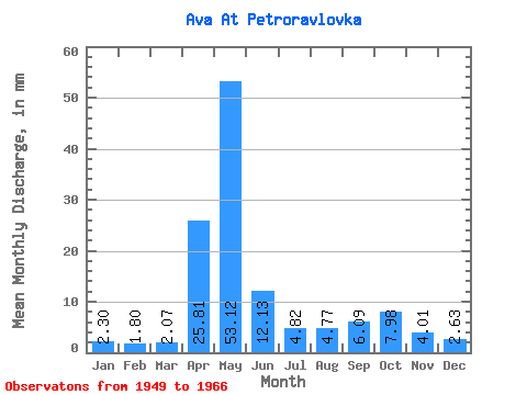
| Statistic | Jan | Feb | Mar | Apr | May | Jun | Jul | Aug | Sep | Oct | Nov | Dec | Annual |
|---|---|---|---|---|---|---|---|---|---|---|---|---|---|
| Mean | 2.30 | 1.81 | 2.06 | 25.81 | 53.12 | 12.12 | 4.82 | 4.77 | 6.09 | 7.98 | 4.01 | 2.62 | 121.59 |
| Standard Deviation | 0.89 | 0.97 | 0.68 | 16.32 | 27.91 | 10.39 | 3.15 | 4.74 | 4.97 | 4.98 | 1.83 | 1.00 | 35.41 |
| Min | 0.90 | 0.76 | 0.90 | 3.61 | 22.98 | 3.86 | 1.74 | 1.29 | 1.93 | 2.64 | 1.81 | 1.09 | 63.92 |
| Max | 4.89 | 4.69 | 3.22 | 60.50 | 124.89 | 48.54 | 13.00 | 22.53 | 22.43 | 20.66 | 8.22 | 5.15 | 167.85 |
| Coefficient of Variation | 0.39 | 0.53 | 0.33 | 0.63 | 0.53 | 0.86 | 0.65 | 0.99 | 0.81 | 0.62 | 0.46 | 0.38 | 0.29 |
 Return to R-Arctic Net Home Page