|
|
|||||||||||||||||
| Point ID: 8644 | Downloads | Plots | Site Data | Code: 11392 |
|
|
|||||||||||||||||
| Download | |
|---|---|
| Site Descriptor Information | Site Time Series Data |
| Link to all available data | |
| View: | Time Series | All |
| Units: | mm |
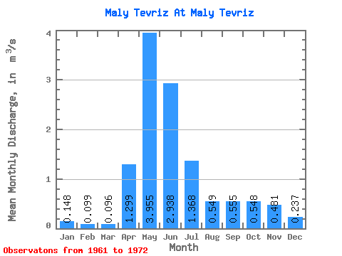
| Statistic | Jan | Feb | Mar | Apr | May | Jun | Jul | Aug | Sep | Oct | Nov | Dec | Annual |
|---|---|---|---|---|---|---|---|---|---|---|---|---|---|
| Mean | 0.15 | 0.10 | 0.10 | 1.30 | 3.96 | 2.94 | 1.37 | 0.55 | 0.56 | 0.55 | 0.48 | 0.24 | 1.03 |
| Standard Deviation | 0.09 | 0.05 | 0.04 | 1.02 | 2.30 | 1.81 | 1.09 | 0.48 | 0.45 | 0.42 | 0.42 | 0.11 | 0.46 |
| Min | 0.08 | 0.04 | 0.00 | 0.34 | 0.86 | 0.55 | 0.20 | 0.25 | 0.24 | 0.22 | 0.21 | 0.11 | 0.29 |
| Max | 0.33 | 0.21 | 0.16 | 3.62 | 9.50 | 5.52 | 3.74 | 1.85 | 1.47 | 1.26 | 1.36 | 0.41 | 1.75 |
| Coefficient of Variation | 0.58 | 0.54 | 0.46 | 0.78 | 0.58 | 0.61 | 0.80 | 0.87 | 0.81 | 0.77 | 0.88 | 0.46 | 0.45 |
 Return to R-Arctic Net Home Page