|
|
|||||||||||||||||
| Point ID: 8644 | Downloads | Plots | Site Data | Code: 11392 |
|
|
|||||||||||||||||
| Download | |
|---|---|
| Site Descriptor Information | Site Time Series Data |
| Link to all available data | |
| View: | Time Series | All |
| Units: | m3/s |
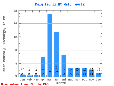
| Statistic | Jan | Feb | Mar | Apr | May | Jun | Jul | Aug | Sep | Oct | Nov | Dec | Annual |
|---|---|---|---|---|---|---|---|---|---|---|---|---|---|
| Mean | 0.70 | 0.43 | 0.46 | 5.98 | 18.81 | 13.53 | 6.51 | 2.61 | 2.56 | 2.61 | 2.21 | 1.13 | 57.81 |
| Standard Deviation | 0.41 | 0.23 | 0.21 | 4.68 | 10.94 | 8.32 | 5.19 | 2.28 | 2.07 | 2.00 | 1.94 | 0.52 | 25.93 |
| Min | 0.39 | 0.19 | 0.01 | 1.56 | 4.09 | 2.53 | 0.95 | 1.19 | 1.10 | 1.05 | 0.97 | 0.52 | 16.34 |
| Max | 1.57 | 0.91 | 0.76 | 16.67 | 45.19 | 25.41 | 17.79 | 8.80 | 6.77 | 5.99 | 6.26 | 1.95 | 98.35 |
| Coefficient of Variation | 0.58 | 0.54 | 0.46 | 0.78 | 0.58 | 0.61 | 0.80 | 0.87 | 0.81 | 0.77 | 0.88 | 0.46 | 0.45 |
 Return to R-Arctic Net Home Page