|
|
|||||||||||||||||
| Point ID: 8641 | Downloads | Plots | Site Data | Code: 11360 |
|
|
|||||||||||||||||
| Download | |
|---|---|
| Site Descriptor Information | Site Time Series Data |
| Link to all available data | |
| View: | Time Series | All |
| Units: | mm |
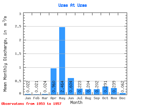
| Statistic | Jan | Feb | Mar | Apr | May | Jun | Jul | Aug | Sep | Oct | Nov | Dec | Annual |
|---|---|---|---|---|---|---|---|---|---|---|---|---|---|
| Mean | 0.02 | 0.02 | 0.02 | 0.96 | 2.46 | 0.60 | 0.22 | 0.20 | 0.20 | 0.29 | 0.24 | 0.06 | 0.44 |
| Standard Deviation | 0.02 | 0.01 | 0.01 | 0.49 | 0.75 | 0.49 | 0.22 | 0.26 | 0.15 | 0.15 | 0.21 | 0.04 | 0.16 |
| Min | 0.00 | 0.01 | 0.01 | 0.48 | 1.51 | 0.23 | 0.07 | 0.06 | 0.08 | 0.07 | 0.04 | 0.01 | 0.35 |
| Max | 0.05 | 0.04 | 0.04 | 1.70 | 3.57 | 1.46 | 0.61 | 0.66 | 0.43 | 0.49 | 0.57 | 0.12 | 0.71 |
| Coefficient of Variation | 0.91 | 0.64 | 0.58 | 0.51 | 0.30 | 0.82 | 1.00 | 1.26 | 0.76 | 0.52 | 0.90 | 0.72 | 0.35 |
 Return to R-Arctic Net Home Page