|
|
|||||||||||||||||
| Point ID: 8641 | Downloads | Plots | Site Data | Code: 11360 |
|
|
|||||||||||||||||
| Download | |
|---|---|
| Site Descriptor Information | Site Time Series Data |
| Link to all available data | |
| View: | Time Series | All |
| Units: | m3/s |
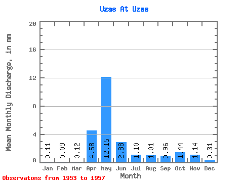
| Statistic | Jan | Feb | Mar | Apr | May | Jun | Jul | Aug | Sep | Oct | Nov | Dec | Annual |
|---|---|---|---|---|---|---|---|---|---|---|---|---|---|
| Mean | 0.11 | 0.09 | 0.12 | 4.58 | 12.15 | 2.88 | 1.10 | 1.00 | 0.96 | 1.43 | 1.14 | 0.30 | 25.75 |
| Standard Deviation | 0.10 | 0.06 | 0.07 | 2.36 | 3.68 | 2.36 | 1.09 | 1.26 | 0.73 | 0.75 | 1.03 | 0.22 | 9.10 |
| Min | 0.00 | 0.04 | 0.04 | 2.29 | 7.45 | 1.10 | 0.35 | 0.31 | 0.38 | 0.36 | 0.21 | 0.05 | 20.18 |
| Max | 0.23 | 0.19 | 0.20 | 8.12 | 17.61 | 6.97 | 3.01 | 3.25 | 2.05 | 2.42 | 2.72 | 0.59 | 41.58 |
| Coefficient of Variation | 0.91 | 0.64 | 0.58 | 0.51 | 0.30 | 0.82 | 1.00 | 1.26 | 0.76 | 0.52 | 0.90 | 0.72 | 0.35 |
 Return to R-Arctic Net Home Page