|
|
|||||||||||||||||
| Point ID: 8634 | Downloads | Plots | Site Data | Code: 11320 |
|
|
|||||||||||||||||
| Download | |
|---|---|
| Site Descriptor Information | Site Time Series Data |
| Link to all available data | |
| View: | Time Series | All |
| Units: | mm |
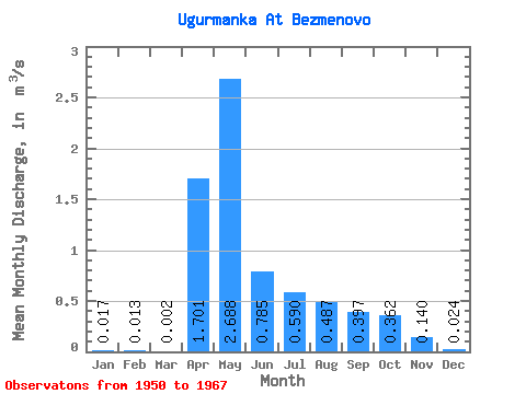
| Statistic | Jan | Feb | Mar | Apr | May | Jun | Jul | Aug | Sep | Oct | Nov | Dec | Annual |
|---|---|---|---|---|---|---|---|---|---|---|---|---|---|
| Mean | 0.02 | 0.01 | 0.00 | 1.70 | 2.69 | 0.79 | 0.59 | 0.49 | 0.40 | 0.36 | 0.14 | 0.02 | 0.43 |
| Standard Deviation | 0.07 | 0.05 | 0.01 | 1.70 | 2.86 | 1.86 | 1.78 | 1.48 | 1.27 | 1.13 | 0.47 | 0.09 | 0.35 |
| Min | 0.00 | 0.00 | 0.00 | 0.00 | 0.06 | 0.00 | 0.00 | 0.00 | 0.00 | 0.00 | 0.00 | 0.00 | 0.07 |
| Max | 0.29 | 0.22 | 0.04 | 5.59 | 11.70 | 7.92 | 7.43 | 6.15 | 5.30 | 4.45 | 1.91 | 0.35 | 1.34 |
| Coefficient of Variation | 4.12 | 4.12 | 4.12 | 1.00 | 1.06 | 2.37 | 3.02 | 3.03 | 3.21 | 3.13 | 3.38 | 3.69 | 0.82 |
 Return to R-Arctic Net Home Page