|
|
|||||||||||||||||
| Point ID: 8634 | Downloads | Plots | Site Data | Code: 11320 |
|
|
|||||||||||||||||
| Download | |
|---|---|
| Site Descriptor Information | Site Time Series Data |
| Link to all available data | |
| View: | Time Series | All |
| Units: | m3/s |
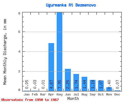
| Statistic | Jan | Feb | Mar | Apr | May | Jun | Jul | Aug | Sep | Oct | Nov | Dec | Annual |
|---|---|---|---|---|---|---|---|---|---|---|---|---|---|
| Mean | 0.05 | 0.04 | 0.01 | 4.87 | 7.95 | 2.25 | 1.75 | 1.44 | 1.14 | 1.07 | 0.40 | 0.07 | 15.00 |
| Standard Deviation | 0.21 | 0.14 | 0.03 | 4.86 | 8.46 | 5.31 | 5.27 | 4.36 | 3.65 | 3.35 | 1.35 | 0.27 | 12.27 |
| Min | 0.00 | 0.00 | 0.00 | 0.00 | 0.18 | 0.00 | 0.00 | 0.00 | 0.00 | 0.00 | 0.00 | 0.00 | 2.27 |
| Max | 0.86 | 0.59 | 0.12 | 15.99 | 34.58 | 22.66 | 21.96 | 18.18 | 15.16 | 13.15 | 5.46 | 1.03 | 46.56 |
| Coefficient of Variation | 4.12 | 4.12 | 4.12 | 1.00 | 1.06 | 2.37 | 3.02 | 3.03 | 3.21 | 3.13 | 3.38 | 3.69 | 0.82 |
 Return to R-Arctic Net Home Page