|
|
|||||||||||||||||
| Point ID: 8609 | Downloads | Plots | Site Data | Code: 11224 |
|
|
|||||||||||||||||
| Download | |
|---|---|
| Site Descriptor Information | Site Time Series Data |
| Link to all available data | |
| View: | Time Series | All |
| Units: | mm |
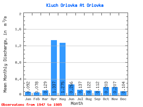
| Statistic | Jan | Feb | Mar | Apr | May | Jun | Jul | Aug | Sep | Oct | Nov | Dec | Annual |
|---|---|---|---|---|---|---|---|---|---|---|---|---|---|
| Mean | 0.09 | 0.08 | 0.13 | 1.34 | 1.27 | 0.27 | 0.14 | 0.12 | 0.11 | 0.20 | 0.21 | 0.10 | 0.34 |
| Standard Deviation | 0.06 | 0.02 | 0.10 | 0.53 | 0.77 | 0.18 | 0.08 | 0.08 | 0.04 | 0.15 | 0.14 | 0.04 | 0.10 |
| Min | 0.04 | 0.04 | 0.05 | 0.48 | 0.30 | 0.08 | 0.05 | 0.04 | 0.05 | 0.05 | 0.05 | 0.04 | 0.16 |
| Max | 0.41 | 0.15 | 0.53 | 2.43 | 3.00 | 0.87 | 0.51 | 0.50 | 0.24 | 0.76 | 0.67 | 0.25 | 0.55 |
| Coefficient of Variation | 0.62 | 0.29 | 0.78 | 0.40 | 0.60 | 0.69 | 0.59 | 0.64 | 0.36 | 0.76 | 0.67 | 0.36 | 0.30 |
 Return to R-Arctic Net Home Page