|
|
|||||||||||||||||
| Point ID: 8609 | Downloads | Plots | Site Data | Code: 11224 |
|
|
|||||||||||||||||
| Download | |
|---|---|
| Site Descriptor Information | Site Time Series Data |
| Link to all available data | |
| View: | Time Series | All |
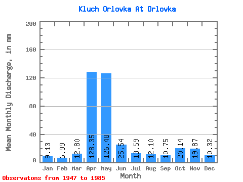
| Units: | m3/s |
| Statistic | Jan | Feb | Mar | Apr | May | Jun | Jul | Aug | Sep | Oct | Nov | Dec | Annual |
|---|---|---|---|---|---|---|---|---|---|---|---|---|---|
| Mean | 9.14 | 7.02 | 12.80 | 128.36 | 126.49 | 25.55 | 13.62 | 12.11 | 10.78 | 20.13 | 19.84 | 10.29 | 395.60 |
| Standard Deviation | 5.68 | 2.01 | 9.91 | 50.99 | 76.28 | 17.58 | 8.09 | 7.74 | 3.89 | 15.35 | 13.28 | 3.75 | 118.72 |
| Min | 4.46 | 3.98 | 5.16 | 46.08 | 29.76 | 7.68 | 4.56 | 4.36 | 4.61 | 4.76 | 4.51 | 4.36 | 190.43 |
| Max | 40.67 | 13.56 | 52.57 | 233.28 | 297.56 | 83.52 | 50.58 | 49.59 | 23.04 | 75.38 | 64.32 | 24.86 | 644.84 |
| Coefficient of Variation | 0.62 | 0.29 | 0.78 | 0.40 | 0.60 | 0.69 | 0.59 | 0.64 | 0.36 | 0.76 | 0.67 | 0.36 | 0.30 |
 Return to R-Arctic Net Home Page