|
|
|||||||||||||||||
| Point ID: 8608 | Downloads | Plots | Site Data | Code: 11223 |
|
|
|||||||||||||||||
| Download | |
|---|---|
| Site Descriptor Information | Site Time Series Data |
| Link to all available data | |
| View: | Time Series | All |
| Units: | mm |
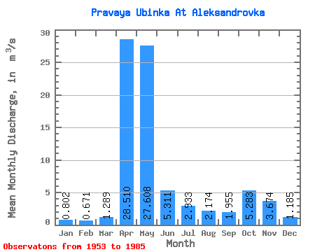
| Statistic | Jan | Feb | Mar | Apr | May | Jun | Jul | Aug | Sep | Oct | Nov | Dec | Annual |
|---|---|---|---|---|---|---|---|---|---|---|---|---|---|
| Mean | 0.80 | 0.67 | 1.29 | 28.51 | 27.61 | 5.31 | 2.93 | 2.17 | 1.96 | 5.28 | 3.67 | 1.19 | 6.88 |
| Standard Deviation | 0.21 | 0.18 | 0.95 | 8.34 | 16.65 | 4.21 | 2.61 | 1.61 | 1.48 | 4.34 | 2.20 | 0.47 | 1.93 |
| Min | 0.39 | 0.39 | 0.48 | 10.00 | 5.18 | 1.04 | 0.61 | 0.33 | 0.64 | 0.79 | 0.78 | 0.47 | 3.86 |
| Max | 1.26 | 1.02 | 4.41 | 46.90 | 62.60 | 15.90 | 12.20 | 7.18 | 8.52 | 20.00 | 8.41 | 2.68 | 10.99 |
| Coefficient of Variation | 0.26 | 0.27 | 0.73 | 0.29 | 0.60 | 0.79 | 0.89 | 0.74 | 0.76 | 0.82 | 0.60 | 0.39 | 0.28 |
 Return to R-Arctic Net Home Page