|
|
|||||||||||||||||
| Point ID: 8608 | Downloads | Plots | Site Data | Code: 11223 |
|
|
|||||||||||||||||
| Download | |
|---|---|
| Site Descriptor Information | Site Time Series Data |
| Link to all available data | |
| View: | Time Series | All |
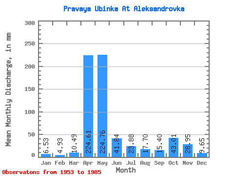
| Units: | m3/s |
| Statistic | Jan | Feb | Mar | Apr | May | Jun | Jul | Aug | Sep | Oct | Nov | Dec | Annual |
|---|---|---|---|---|---|---|---|---|---|---|---|---|---|
| Mean | 6.53 | 4.98 | 10.49 | 224.62 | 224.73 | 41.84 | 23.88 | 17.70 | 15.40 | 43.01 | 28.95 | 9.65 | 659.99 |
| Standard Deviation | 1.70 | 1.33 | 7.71 | 65.73 | 135.56 | 33.13 | 21.22 | 13.12 | 11.65 | 35.34 | 17.36 | 3.79 | 185.22 |
| Min | 3.17 | 2.89 | 3.91 | 78.78 | 42.16 | 8.19 | 4.96 | 2.69 | 5.04 | 6.43 | 6.14 | 3.83 | 369.88 |
| Max | 10.26 | 7.56 | 35.90 | 369.50 | 509.55 | 125.27 | 99.31 | 58.44 | 67.12 | 162.80 | 66.26 | 21.82 | 1053.84 |
| Coefficient of Variation | 0.26 | 0.27 | 0.73 | 0.29 | 0.60 | 0.79 | 0.89 | 0.74 | 0.76 | 0.82 | 0.60 | 0.39 | 0.28 |
 Return to R-Arctic Net Home Page